MAWM — Most Accurate World Map
- By
Lore-accurate, realigned 4K Azeroth World Map (UiMapID 947) built from official Blizzard CASC tiles with native golden coastline highlights, click-to-zoom navigation, WC3 fleet routes, and all 11 client locales.
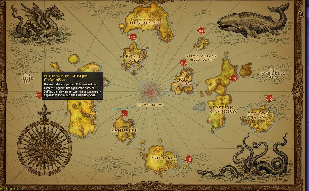
EN_Screenshot_1_FullMap_Pin1.jpg
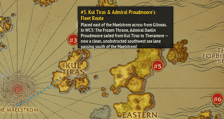
EN_Screenshot_2_KulTiras_Pin3.png
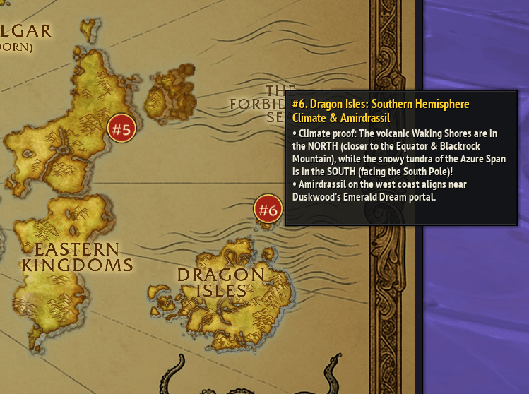
EN_Screenshot_3_DragonIsles_Pin6.png
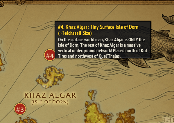
EN_Screenshot_4_KhazAlgar_Pin4.png
Description
MAWM — Most Accurate World Map
MAWM (Most Accurate World Map) overhauls the Azeroth World Map (UiMapID = 947) to fix 20 years of expansion continent cramming, inverted climate zones, broken Pre-Sundering borders, and impossible naval routes — while keeping 100% interactive click-to-zoom continent navigation, 1:1 pixel-locked Blizzard golden coastline highlights, and automatic map typography for all 11 official World of Warcraft client locales.
Why Azeroth Needed a Cartographic Realignment
- True Planetary Ocean Margins (The Veiled Sea & The Forbidding Sea):
- Kalimdor and the Eastern Kingdoms are shifted inward from the frame edges so Azeroth reads as a true planetary projection with wide oceans rather than continents squeezed against a picture frame, with The Maelstrom centered at the exact
(50%, 50%)equator.
- Kalimdor and the Eastern Kingdoms are shifted inward from the frame edges so Azeroth reads as a true planetary projection with wide oceans rather than continents squeezed against a picture frame, with The Maelstrom centered at the exact
- Broken Isles (
619) Off the Coast of Azshara:- Azsuna's Highborne ruins now connect directly to Azshara.
- Highmountain's snowy peaks face Borean Tundra in Northrend.
- Suramar & the Broken Shore face directly into The Maelstrom.
- Khaz Algar (
2274) — Surface Isle of Dorn East of Northrend:- On the surface world map, Khaz Algar is only the Isle of Dorn (since over 75% of Khaz Algar — The Ringing Deeps, Hallowfall, Azj-Kahet — is subterranean).
- Placed east of Northrend along the Ulduar / Storm Peaks Titan forge belt.
- Kul Tiras (
876) & Admiral Daelin Proudmoore's Fleet Route:- Placed in the central sea east of the Maelstrom.
- Restores Admiral Daelin Proudmoore's Warcraft III: The Frozen Throne (Founding of Durotar) naval route: sailing southwest from Kul Tiras to Theramore and Durotar through open southern waters without ever crossing the Maelstrom.
- Dragon Isles (
1978) in the Southern Hemisphere (Southeast of the Eastern Kingdoms):- Placed southeast of Burning Steppes, Badlands, and Twilight Highlands.
- Southern Hemisphere Climate Proof: On Blizzard's stock map (where Dragon Isles is in the far north), its internal climate is completely upside-down. In the Southern Hemisphere, it finally makes 100% physical sense: the volcanic Waking Shores are in the north (closer to the Equator & Blackrock Mountain), while the snowy tundra of The Azure Span is in the south (closer to the South Pole), and Amirdrassil on the west coast aligns near Duskwood's Emerald Dream portal.
- Zandalar (
875) as South America & Deep Southern Pandaria (424):- Zandalar sits southwest of the Maelstrom as Azeroth's South American continent.
- Pandaria sits deep in the southern ocean: its snowy Kun-Lai Summit is in the north, and the continent avoids freezing over at its southern polar latitude thanks to the Titan/Mogu geothermal and arcane heat source at its center — the Vale of Eternal Blossoms (waters of the Well of Eternity).
Features
- Automatic Multi-Language Map Typography (All 11 Official WoW Client Locales):
- Automatically detects your WoW client language (
GetLocale()) and renders authentic engraved continent & sea labels in English (enUS/enGB), Russian (ruRU), German (deDE), French (frFR), Spanish (esES/esMX), Italian (itIT), Portuguese (ptBR), Korean (koKR), Simplified Chinese (zhCN), and Traditional Chinese (zhTW).
- Automatically detects your WoW client language (
- 2 Bundled High-Res (
3072x2048) Map Styles:- Official 4K Blizzard CASC Realigned (
blizz— Default): Exact continent stencils extracted from genuine BlizzardUiMapArtID 970 / 17924K tiles on a warm golden-amber cartographer's parchment ocean with engraved sea serpents, leviathan, kraken, and compass rose. - Cartographer's Illustrated Parchment (
carto): Unified warm antique parchment map style.
- Official 4K Blizzard CASC Realigned (
- 1:1 Pixel-Locked Golden Coastline Highlights:
- Uses Blizzard's native
HighlightFileDataIDcontinent masks fromUiMapAssignment.db2aligned with zero pixel drift to each continent's realigned coordinates on hover.
- Uses Blizzard's native
- Toggleable Lore & Naval Fleet Route Overlay (
[Lore]):- Displays Admiral Daelin Proudmoore's fleet path, tectonic & climate vectors, and interactive
#1-#8geodesy pins with full English & Russian tooltips.
- Displays Admiral Daelin Proudmoore's fleet path, tectonic & climate vectors, and interactive
- One-Click Map Button &
/mawm(/meow) Commands:- Left-Click: Toggle Realigned vs. Stock Map
- Right-Click: Switch Style (
4K Blizz/Parchment) - Alt-Click: Switch Map Language (
Client Auto/EN/RU, or/mawm lang <code>) - Shift-Click / Middle-Click: Toggle Lore & Naval Routes Overlay
Roadmap & Known Limitations (v1.3.1)
- World Map Pins & Addon Markers on Top-Level Azeroth (
UiMapID = 947):- Currently, stock game pins and third-party addon markers on the top-level Azeroth World Map (
947) are hidden whileMAWMis active so misplaced stock pins don't float in the ocean. Dynamic coordinate remapping for addon pins & waypoints on947is in active development for a future update. - (Inside all zoomed-in Continent and Zone maps, all game pins, waypoints, and map addons work 100% normally.)
- Currently, stock game pins and third-party addon markers on the top-level Azeroth World Map (
MAWM — Most Accurate World Map Team