EarthStream — Real World Generation
- By
Pick a real place, choose your spawn and explore beyond it. EarthStream brings Arnis terrain into Minecraft, with an atlas and generation as you travel.
atlas-selection-neoforge-1.21.1.png
atlas-zoom-fabric-1.21.1.png
Description
EarthStream — Real World Generation
Start in a place you know. Pick your hometown, a coastline or somewhere you've always wanted to visit, then build and explore there in Minecraft.
EarthStream uses Arnis to turn geographic data into terrain, streets, buildings and waterways. Choose a starting area on the map; more terrain is prepared as you travel beyond it. Your saved chunks and buildings stay yours.
Make your first world
- Open Singleplayer → Create New World and select the Real world world type.
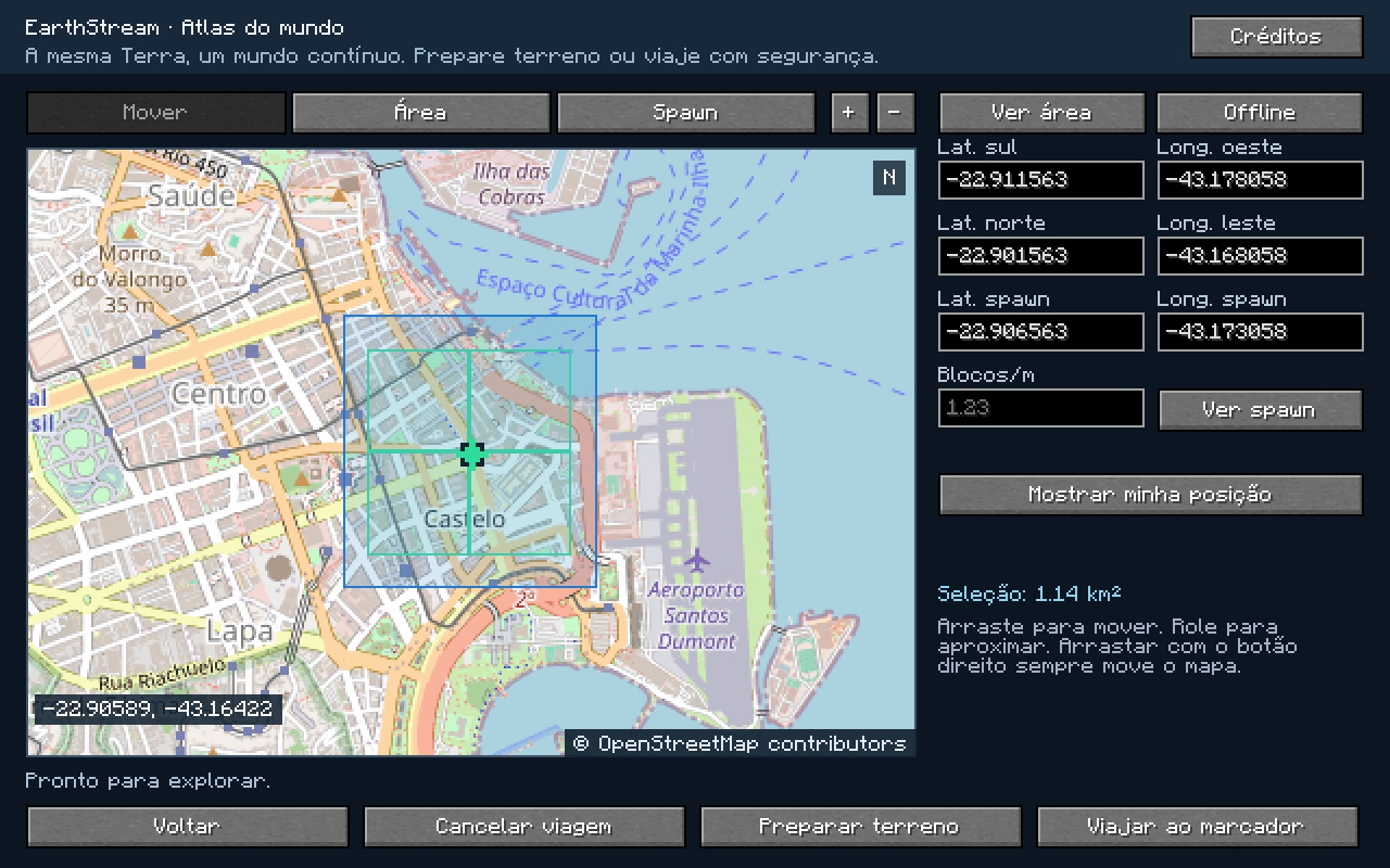
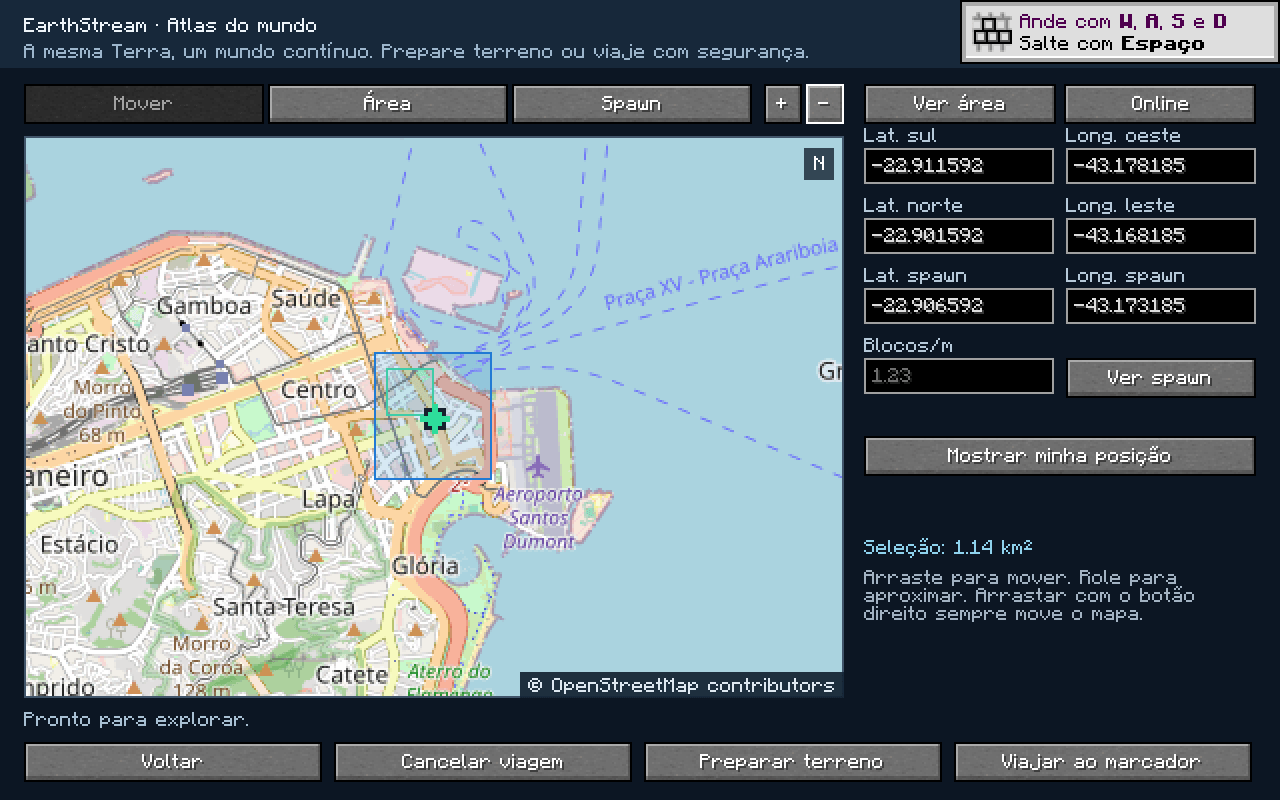
- Click Customize. Move and zoom the map, then select Area and drag a small rectangle.
- Select Spawn and place the marker on land inside it. You can also type coordinates.
- Set the scale: 0.30–4.00 blocks per meter. At 1.00, one block is approximately one meter near your starting point.
- Use Online for a new location, or Offline if its terrain has already been prepared.
- Click Done, finish your usual world settings, then Create New World.
Your name, mode, seed, rules and other vanilla options are preserved. Preparation shows progress and allows cancellation or retry. The spawn marker sets the geographic origin; you may start on safe ground nearby. If no safe spot is available, choose another marker.
Keep going
The rectangle you choose is a starting area, not a fence. Walk beyond it and EarthStream requests the next real regions. You can also prepare a destination in the atlas before setting out.
New terrain can take time, particularly in dense cities. Start small and let preparation finish before a long trip. If data is unavailable, you may need to wait or retry; missing geography is never replaced with flat or vanilla terrain.
The world's origin, scale and generation settings stay fixed so neighboring regions use the same coordinates. Already saved chunks take priority over generation, preserving your construction when you return.
Use the atlas
Press M while connected to open it; the key can be changed in Controls. The Esc menu also has an atlas button in singleplayer and for server operators with permission level 1 or higher.
Select an area and use Prepare, or place a marker and request a trip. Atlas travel waits for terrain and looks for safe ground. Cancelling a pending trip keeps you where you are.
Travel, preparation and changing terrain Offline mode require OP2 permission. This also applies in singleplayer: enable cheats/commands to use those actions. LAN guests need the same permission. Opening the map alone does not require OP2.
The geographic /earth tp command finds safe ground. Vanilla /tp retains its normal permissions and your requested coordinates and orientation, including fractional positions and explicit Y. It waits for the chunk, but an unsafe Y can still leave you airborne or inside blocks.
Install the right version
Version 0.1.1 has five builds. Put one matching JAR in your instance's mods folder. Do not combine builds or install the -sources.jar.
| Minecraft Java | Tested loader | Java | File |
|---|---|---|---|
| 26.3 | NeoForge 26.3.0.101 | 25 | earthstream-neoforge-26.3-0.1.1.jar |
| 1.21.1 | NeoForge 21.1.235 | 21 | earthstream-neoforge-1.21.1-0.1.1.jar |
| 1.21.1 | Fabric Loader 0.19.3 | 21 | earthstream-fabric-1.21.1-0.1.1.jar |
| 1.20.1 | Forge 47.4.20 | 17 | earthstream-forge-1.20.1-0.1.1.jar |
| 1.20.1 | Fabric Loader 0.19.3 | 17 | earthstream-fabric-1.20.1-0.1.1.jar |
Windows x64 is required by the bundled generator, including on a server generating terrain. Linux, macOS and other architectures are not included. Use matching Minecraft, loader and mod versions on client and server.
Arnis is included; no separate Arnis, Rust or Python installation is needed. Fabric API is bundled too: 0.116.17+1.21.1 or 0.92.12+1.20.1. The table lists tested loaders, not a guarantee for every version allowed by metadata.
Offline play and backups
Offline terrain mode uses saved Minecraft chunks and completed regions in the EarthStream cache. Raw downloaded data alone is not ready-to-play terrain. Cancelled preparation keeps regions that have finished.
Map pictures use a separate cache. Terrain Offline mode neither downloads an offline atlas nor disables map-image requests. Uncached pictures may still need internet; coordinate fields remain usable.
Back up your world and its corresponding terrain cache. Keep the matching generation profile and data: incompatible or missing source data must be restored, not replaced with a different version. Keep worlds separate across Minecraft versions and loaders; migration has not been validated.
A few things to know
- This is a Minecraft interpretation of geographic data, not an exact reconstruction. Architecture, interiors, bridges and vegetation are approximate; some climate/style choices follow the starting location.
- The Web Mercator projection uses X east and Z south. Distances match the chosen scale near the origin and distort farther away.
- Coordinates range from −85° to +85° latitude and −180° to +180° longitude. Entire generation regions must fit, so locations close to the edges may be refused. There is no date-line wrapping; Minecraft's limits and world borders still apply.
- Height spans Y −2032 to 2031, using transformed elevation rather than literal meters above sea level.
- Optional 3D schematic decorations and some optional data layers are disabled. Procedural buildings, roads, farms, pools, bridges, solar panels and terrain remain.
- Large areas need more time, memory and disk space. Older builds substitute certain unavailable blocks; unsupported states fail explicitly rather than becoming air.
Packaged-server tests and in-game checks cover creation, travel, persistence and offline reopening; real and synthetic regions were compared across boundaries. They do not cover every location. Real multiplayer client sessions, shaders and arbitrary modpacks have not been validated.
Credits
EarthStream uses Arnis 3.4.0 by Louis Erbkamm (louis-e) and contributors, with EarthStream changes. Apache License 2.0 notices are preserved; source JARs include the worker patch and rebuild instructions.
Map and geography: © OpenStreetMap contributors, under the ODbL. Data terms are separate from the software license.
Elevation: AWS Terrain Tiles / Mapzen and the original providers in the attribution list.
Land cover: ESA WorldCover 2021 v200. © ESA WorldCover project 2021 / Contains modified Copernicus Sentinel data (2021) processed by ESA WorldCover consortium. CC BY 4.0; data and attribution.
The atlas Credits screen and bundled notices retain Arnis's asset/dependency credits, Rust notices, LGPL materials for MC2MT by rollerozxa, and Fabric API notices. See LICENSE, THIRD_PARTY_NOTICES.txt and earthstream/native/.
All screenshots above are genuine, unedited game captures. The separate project icon is AI-generated branding, not gameplay. EarthStream is independent and is not endorsed by Arnis, Mojang or Microsoft.
Found a problem?
Please include Minecraft, loader and EarthStream versions, your operating system, coordinates, scale, Online/Offline setting, reproduction steps and the relevant log. Say whether it happened during preparation, travel or reopening.
EarthStream — Real World Generation Team

Owner